

Land Survey Equipment Market Report 2026
Global Outlook – By Solution (Hardware, Software, Services), By Product (Global Navigation Satellite System (GNSS), Total Stations And Theodolites, Levels, 3D Laser Or Laser Scanners, Unmanned Aerial Vehicles (UAVs), Other Products), By Application (Inspection, Monitoring, Volumetric Calculations, Layout Points, Other Applications), By End User (Commercial, Defense, Service Providers), By Industry (Transportation, Energy And Power, Mining And Construction, Forestry, Scientific And Geological Research, Precision Agriculture, Disaster Management, Other Industries) – Market Size, Trends, Strategies, and Forecast to 2035
Land Survey Equipment Market Overview
• Land Survey Equipment market size has reached to $8.78 billion in 2025 • Expected to grow to $12.65 billion in 2030 at a compound annual growth rate (CAGR) of 7.5% • Growth Driver: Growth In The Construction Industry Is Anticipated To Fuel The Land Survey Equipment Market • Market Trend: Advanced Technology To Provide A Precise Surveying Experience • Asia-Pacific was the largest region in 2025.Market Gains By 2030 – Top Opportunities By Segment
Market Gain identifies the most promising market opportunities by highlighting the segments or products expected to generate the highest incremental revenue growth over the next five years.
What Is Covered Under Land Survey Equipment Market?
The land survey equipment refers to the equipment, used for surveys including measuring land and locating the land, both natural features and man-made using the principle of mathematics, geometry, and other sciences. The main products in land survey equipment market are GNSS systems, total stations and theodolites, levels, 3D laser/laser scanners, unmanned aerial vehicles (UAVs), and other products. The GNSS systems refer to the Global Navigation Satellite System (GNSS) as any satellite constellation that provides global or regional positioning, navigation, and timing (PNT) services. The land survey equipment market has applications in inspection, monitoring, volumetric calculations, layout points, and others. These are used in various industries such as transportation, energy and power, mining and construction, forestry, scientific and geological research, and precision agriculture, disaster management, and other industries. The various solutions are hardware, software, and services. The various end-users are commercial, defense, and service providers.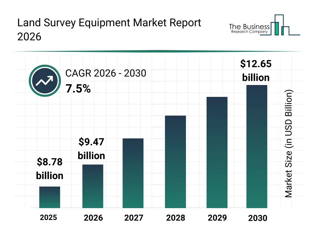
What Is The Land Survey Equipment Market Size and Share 2026?
The land survey equipment market size has grown strongly in recent years. It will grow from $8.78 billion in 2025 to $9.47 billion in 2026 at a compound annual growth rate (CAGR) of 7.8%. The growth in the historic period can be attributed to infrastructure development projects, expansion of construction activities, demand for accurate land mapping, growth in mining operations, adoption of modern surveying tools.What Is The Land Survey Equipment Market Growth Forecast?
The land survey equipment market size is expected to see strong growth in the next few years. It will grow to $12.65 billion in 2030 at a compound annual growth rate (CAGR) of 7.5%. The growth in the forecast period can be attributed to smart city development projects, adoption of autonomous surveying systems, growth of geospatial analytics, investments in infrastructure monitoring, demand for real-time land data. Major trends in the forecast period include integration of gnss-based surveying, adoption of uav-based mapping, demand for high-precision measurement, growth of digital surveying software, automation of land survey operations.

Global Land Survey Equipment Market Segmentation
1) By Solution: Hardware, Software, Services 2) By Product: Global Navigation Satellite System (GNSS), Total Stations And Theodolites, Levels, 3D Laser Or Laser Scanners, Unmanned Aerial Vehicles (UAVs), Other Products 3) By Application: Inspection, Monitoring, Volumetric Calculations, Layout Points, Other Applications 4) By End User: Commercial, Defense, Service Providers 5) By Industry: Transportation, Energy And Power, Mining And Construction, Forestry, Scientific And Geological Research, Precision Agriculture, Disaster Management, Other Industries Subsegments: 1) By Hardware: Total Stations, Theodolites, GNSS/GPS Receivers, Levels, Laser Scanners (LiDAR) 2) By Software: Surveying & Mapping Software, GIS Software, CAD Software, 3D Modeling Software, Data Processing Software, Land Management Software, Cloud-Based Survey Software 3) By Services: Surveying Services, Installation & Calibration, Maintenance & Repair, Training & Consulting, Data Processing Services, Software Support & Upgrades, Equipment Rental & Leasing The top segments in the land survey equipment market will be: • Hardware will reach $5349.8 Million by 2025. • Total Stations and Theodolites will reach $2921.5 Million by 2025. • Layout Points will reach $2684.7 Million by 2025. • Global Navigation Satellite System (GNSS) will reach $2635.3 Million by 2025. • Inspection will reach $2038.5 Million by 2025.What Is The Driver Of The Land Survey Equipment Market?
The growth in the construction industry is expected to propel the growth of the land survey equipment market going forward. The construction industry is the planning, design, and execution of building structures and infrastructure projects, encompassing residential, commercial, and civil engineering activities. Land survey equipment is used for construction to accurately map and measure land features, ensuring precise foundation placement and adherence to project specifications. For instance, in November 2024, according to the Office for National Statistics (ONS), a UK-based government agency, the value of new construction work in Great Britain rose to US$ 182.5 billion (£139,029 million) in 2023, up from US$ 174.5 billion (£132,989 million) in 2022. Therefore, the growth in the construction industry is driving the land survey equipment industry.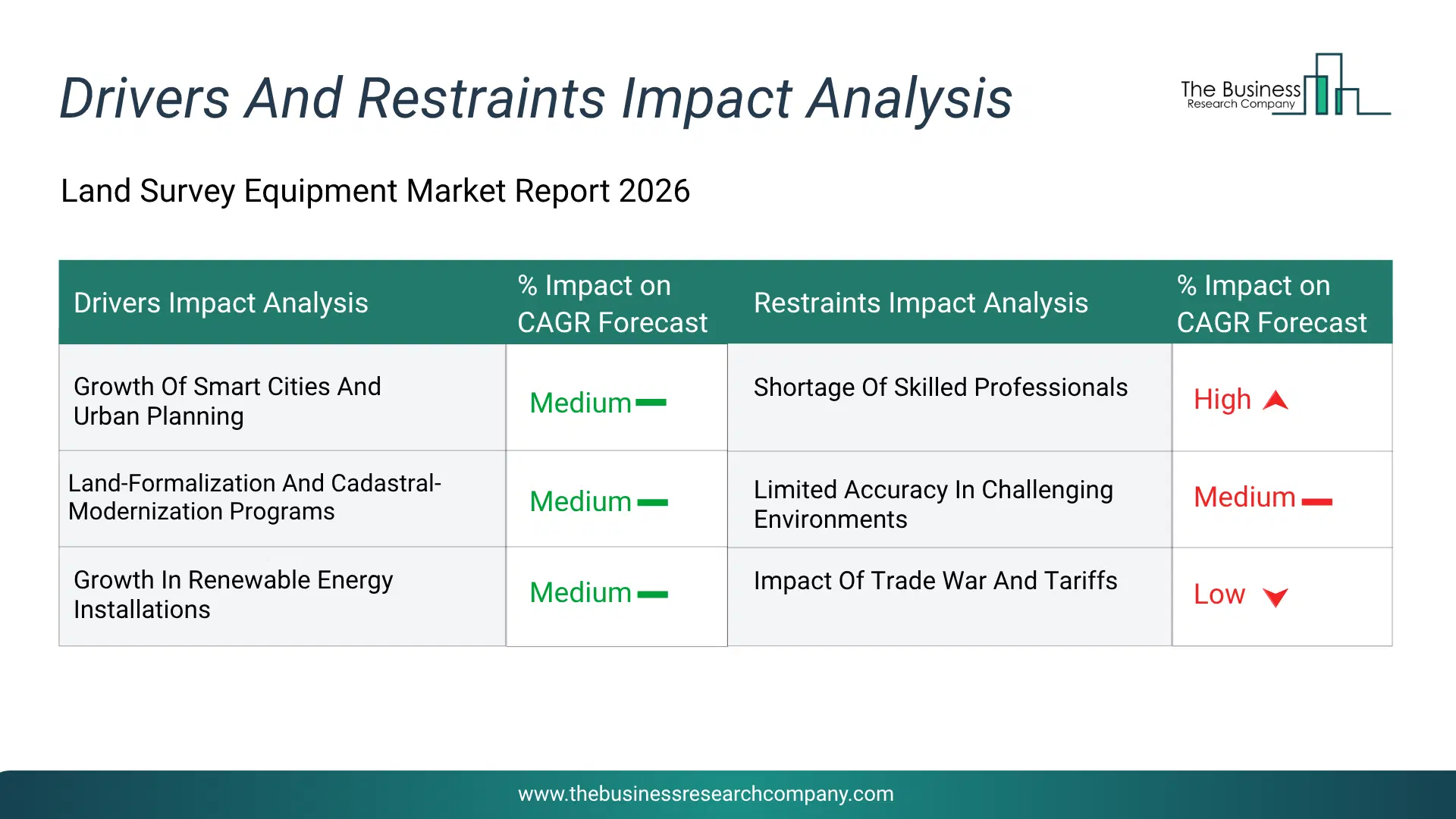
Infographic Chart Showing Key Market Drivers Analysis And Restraints For Land Survey Equipment Market
The chart presents an impact analysis of key drivers and restraints, quantifying their relative influence on the market's growth rate and helping assess the balance between growth enablers and limiting factors. This chart offers a high-level perspective; the full report contains more detailed insights.
How Will The Drivers Impact Growth In The Global Land Survey Equipment Market?
• Growth Of Smart Cities And Urban Planning (Medium) – The growth of smart cities and urban planning will become a key driver of growth in the land survey equipment market by 2030. Rapid urbanization, coupled with increasing government investments in smart infrastructure creates the strong demand for precise geospatial data to support efficient city development and management. Smart cities integrate digital technologies, data analytics, and connected systems to optimize urban services such as transportation, utilities, housing, and public safety. Land survey equipment plays a vital role in smart city development by enabling accurate mapping, 3D modeling, and spatial data collection required for urban planning and infrastructure design. Technologies such as GNSS, LiDAR, and total stations are used to create detailed digital maps, support building information modeling (BIM), and ensure proper alignment of infrastructure projects. These tools help planners design sustainable, efficient, and resilient urban environments. Therefore, the rising adoption of smart city concepts and the growing focus on data-driven urban planning are key factors contributing to the expansion of the land survey equipment market. As a result, the growth of smart cities and urban planning is anticipated to contributing to a 1.5% annual growth in the market. • Land-Formalization And Cadastral-Modernization Programs (Medium) – The land-formalization and cadastral-modernization programs will emerge as a major factor driving the expansion of the land survey equipment market by 2030. Governments across developed and developing economies are increasingly prioritizing the formal registration of land ownership and the modernization of outdated cadastral systems to improve land governance, enhance tenure security, and reduce land-related disputes. These programs involve the systematic mapping, documentation, and digitization of land parcels, which require highly accurate and efficient surveying technologies such as GNSS systems, total stations, and 3D laser scanners. Land survey equipment enables precise boundary demarcation, geospatial data collection, and integration into digital land information systems, ensuring transparency and reliability in land records. Moreover, international initiatives supported by organizations such as the World Bank Group and the Food and Agriculture Organization are promoting land administration reforms and providing funding and technical assistance for cadastral modernization projects. These efforts are particularly prominent in emerging economies, where informal land ownership remains widespread. As countries continue to invest in land formalization and digital cadastral systems, the demand for advanced land survey equipment is expected to rise, thereby contributing to the overall expansion of the market. Consequently, the land-formalization and cadastral-modernization programs is projected to contributing to a 1.3% annual growth in the market. • Growth In Renewable Energy Installations (Medium) – The growth in renewable energy installations will serve as a key growth catalyst for the land survey equipment market by 2030. Increasing global focus on reducing carbon emissions and transitioning toward sustainable energy sources has accelerated the development of renewable energy projects such as solar farms, wind farms, and hydropower plants. These projects require extensive land assessment, site planning, and precise measurements, thereby increasing the demand for advanced surveying solutions. Land survey equipment plays a critical role in renewable energy development by enabling accurate site selection, topographic mapping, and alignment of infrastructure. Technologies such as GNSS systems, drones, and LiDAR are used to analyze terrain, optimize panel or turbine placement, and ensure efficient energy generation. Additionally, surveying tools help identify environmental constraints, minimize risks, and support regulatory compliance throughout project execution. As the deployment of renewable energy infrastructure continues to rise globally, the need for precise and reliable land survey equipment is expected to grow, thereby contributing to the overall expansion of the market. Therefore, this growth in renewable energy installations is projected to supporting to a 1.0% annual growth in the market. • Rising Need For Disaster Management And Environmental Monitoring (Low) – The rising need for disaster management and environmental monitoring will become a significant driver contributing to the growth of the land survey equipment market by 2030. Increasing occurrences of natural disasters such as floods, earthquakes, landslides, and hurricanes, along with growing concerns over climate change, have heightened the demand for accurate geospatial data. Land survey equipment plays a crucial role in disaster preparedness, risk assessment, and post-disaster recovery by enabling precise mapping of affected areas, monitoring terrain changes, and supporting early warning systems. Additionally, environmental monitoring initiatives, such as tracking deforestation, soil erosion, coastal changes, and water resource management—require advanced surveying technologies to collect reliable and real-time data. Governments and organizations are increasingly investing in sustainable development and climate resilience programs, further boosting the adoption of modern land survey equipment. Therefore, the growing emphasis on disaster risk reduction and environmental sustainability is expected to accelerate demand for land survey equipment, contributing to overall market expansion. Consequently, the rising need for disaster management and environmental monitoring is projected to contributing to a 0.8% annual growth in the market.How Will The Restraints Impact Growth In The Global Land Survey Equipment Market?
• Shortage Of Skilled Professionals (Medium) – Shortage of skilled professionals is expected to restrain market growth during the forecast period. It creates operational, financial, regulatory, or commercial challenges that can increase costs, delay projects, reduce investments, or discourage purchasing decisions depending on the market. These challenges can reduce product adoption, affect business confidence, and limit the ability of companies to expand efficiently across key regions. This can reduce operational efficiency, delay expansion plans, and affect the ability of companies to achieve sustainable business growth. • Limited Accuracy In Challenging Environments (Medium) – During the forecast period, limited accuracy in challenging environments is likely to limit market expansion. It creates operational, financial, regulatory, or commercial challenges that can increase costs, delay projects, reduce investments, or discourage purchasing decisions depending on the market. These challenges can reduce product adoption, affect business confidence, and limit the ability of companies to expand efficiently across key regions. As a result, businesses may face increased cost pressures, slower commercial adoption, and reduced revenue opportunities. • Impact Of Trade War And Tariffs (Medium) – The market is expected to face challenges due to impact of trade war and tariffs over the forecast period. It creates operational, financial, regulatory, or commercial challenges that can increase costs, delay projects, reduce investments, or discourage purchasing decisions depending on the market. These challenges can reduce product adoption, affect business confidence, and limit the ability of companies to expand efficiently across key regions. This may discourage new investments, delay strategic expansion initiatives, and weaken the overall competitive position of market participants.Key Players In The Global Land Survey Equipment Market
Major companies operating in the land survey equipment market are Hexagon AB, Garmin Ltd., Trimble Inc., Fugro NV, MiTAC Digital Corporation, Topcon Corporation, Leica Geosystems AG, Shanghai Huace Navigation Technology Ltd., Suzhou FOIF Co Ltd., CHC Navigation Hudaco Industries Limited, Novatel Inc., M&P Survey Equipment Ltd., GeoMax AG, Ansari Precision Instruments Private Limited, Kolida Instrument Co Ltd., Survey Copter, Changzhou Dadi Surveying Science And Technology Co Ltd., Sokkia Co Ltd., PASI Srl, South Surveying And Mapping Instruments Co Ltd., Hi-Target Surveying Instrument Co Ltd., V.I Instruments Industries Limited, Geotrax International Services Inc., Jafri Survey Instruments
This chart is for illustrative purposes; the full report includes a detailed competitor analysis and comprehensive overview of the top 10 companies in the market.

This chart maps companies by product innovation and brand strength, with bubble size indicating relative revenue, helping identify market leaders, challengers, and niche players. This is an illustrative chart; the full report provides a complete and accurate competitive analysis.
Global Land Survey Equipment Market Trends and Insights
Major companies in the land survey equipment market are focused on developing advanced technology, such as GNSS RTK receivers and hybrid total-station systems, to provide a precise surveying experience and gain a competitive edge. GNSS RTK (global navigation satellite system real-time kinematic) technology is a high-precision positioning technique that utilizes satellite signals for real-time, centimeter-level (or near-centimeter-level) accuracy in surveying and mapping applications. For instance, in June 2024, Trimble, a U.S.-based technology company, introduced the Trimble R980 GNSS system, a next-generation GNSS receiver built upon their ProPoint positioning engine, with enhanced communication (dual-band UHF + integrated worldwide LTE modem), improved RTK correction reception (local base station, VRS network, or satellite/internet via RTX), tilt-compensation via IMU (so the pole need not be perfectly vertical), and improved mitigation of ionospheric and multipath disturbances all designed to enable reliable high-precision GNSS surveying even under challenging conditions (urban canyons, tree cover, etc.).What Are Latest Mergers And Acquisitions In The Land Survey Equipment Market?
In February 2024, Leica Geosystems, a Switzerland-based measurement and surveying technology company, partnered with John Deere. This partnership aimed to bring new solutions to the construction industry. Deere & Company, commonly known as John Deere, is a US-based manufacturer of agricultural machinery, heavy equipment, and forestry machinery.
Regional Outlook
Asia-Pacific was the largest region in the land survey equipment market in 2025. The regions covered in this market report are Asia-Pacific, South East Asia, Western Europe, Eastern Europe, North America, South America, Middle East, Africa The countries covered in this market report are Australia, Brazil, China, France, Germany, India, Indonesia, Japan, Taiwan, Russia, South Korea, UK, USA, Canada, Italy, Spain.What Defines the Land Survey Equipment Market?
The land survey equipment market consists of sales of chains and tapes, compasses and clinometers, transits, levels, safety gear, prisms and reflectors, magnetic locators, poles, tripods, and mounts. Values in this market are ‘factory gate’ values, that is the value of goods sold by the manufacturers or creators of the goods, whether to other entities (including downstream manufacturers, wholesalers, distributors and retailers) or directly to end customers. The value of goods in this land survey equipment market includes related services sold by the creators of the goods.How is Market Value Defined and Measured?
The market value is defined as the revenues that enterprises gain from the sale of goods and/or services within the specified market and geography through sales, grants, or donations in terms of the currency (in USD unless otherwise specified). The revenues for a specified geography are consumption values that are revenues generated by organizations in the specified geography within the market, irrespective of where they are produced. It does not include revenues from resales along the supply chain, either further along the supply chain or as part of other products.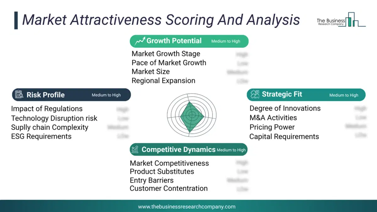
This chart presents market attractiveness based on a quantitative evaluation of growth, competition, strategic alignment, and risk, offering a clear view of opportunity areas for decision-making. This chart is for illustrative purposes; the full report contains the complete analysis.
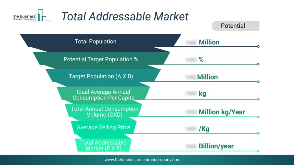
This chart highlights the Total Addressable Market (TAM) by estimating the maximum revenue opportunity using an assumption-driven approach, supporting strategic planning and opportunity sizing across markets. The chart is illustrative; the full report provides a more comprehensive analysis.
What Key Data and Analysis Are Included in the Land Survey Equipment Market Report 2026?
The land survey equipment market research report is one of a series of new reports from The Business Research Company that provides market statistics, including industry global market size, regional shares, competitors with the market share, detailed market segments, market trends and opportunities, and any further data you may need to thrive in the land survey equipment industry. The market research report delivers a complete perspective of everything you need, with an in-depth analysis of the current and future state of the industry.Land Survey Equipment Market Report Forecast Analysis
| Report Attribute | Details |
|---|---|
| Market Size Value In 2026 | $9.47 billion |
| Revenue Forecast In 2035 | $12.65 billion |
| Growth Rate | CAGR of 7.8% from 2026 to 2035 |
| Base Year For Estimation | 2025 |
| Actual Estimates/Historical Data | 2020-2025 |
| Forecast Period | 2026 - 2030 - 2035 |
| Market Representation | Revenue in USD Billion and CAGR from 2026 to 2035 |
| Segments Covered | Solution, Product, Application, End User, Industry |
| Regional Scope | Asia-Pacific, Western Europe, Eastern Europe, North America, South America, Middle East, Africa |
| Country Scope | The countries covered in the report are Australia, Brazil, China, France, Germany, India, ... |
| Key Companies Profiled | Hexagon AB, Garmin Ltd., Trimble Inc., Fugro NV, MiTAC Digital Corporation, Topcon Corporation, Leica Geosystems AG, Shanghai Huace Navigation Technology Ltd., Suzhou FOIF Co Ltd., CHC Navigation Hudaco Industries Limited, Novatel Inc., M&P Survey Equipment Ltd., GeoMax AG, Ansari Precision Instruments Private Limited, Kolida Instrument Co Ltd., Survey Copter, Changzhou Dadi Surveying Science And Technology Co Ltd., Sokkia Co Ltd., PASI Srl, South Surveying And Mapping Instruments Co Ltd., Hi-Target Surveying Instrument Co Ltd., V.I Instruments Industries Limited, Geotrax International Services Inc., Jafri Survey Instruments |
| Customization Scope | Request for Customization |
| Pricing And Purchase Options | Explore Purchase Options |