

Satellite Imagery Market Report 2026
Global Outlook – By Type (0.3 Meter Resolution, 0.5 Meter Resolution, 1 Meter Resolution), By Application (Geospatial Data Acquisition, Navigation And Mapping), By End User (Government, Defense) – Market Size, Trends, Strategies, and Forecast to 2030
Satellite Imagery Market Overview
• Satellite Imagery market size has reached to $2.4 billion in 2025 • Expected to grow to $5.36 billion in 2030 at a compound annual growth rate (CAGR) of 17.4% • Growth Driver: Expansion of Government & Defense Applications Driving The Market Growth Due To Increased Investment in Space-Based Intelligence Systems • Market Trend: Advancements In OptoSAR Satellite Technology Enhance Real-Time Earth Observation And Imaging Capabilities • North America was the largest region in 2025 and Asia-Pacific is the fastest growing region.What Is Covered Under Satellite Imagery Market?
Satellite Imagery refers to Earth observation images and data captured by satellites using advanced sensors such as optical, radar, and infrared technologies. It enables accurate monitoring of land, oceans, weather patterns, infrastructure, and environmental changes from space. The primary purpose of satellite imagery is to support defense surveillance, environmental analysis, agriculture management, disaster response, urban planning, and natural resource monitoring. The main types of satellite imagery include 0.3 meter resolution, 0.5 meter resolution, and 1 meter resolution. 0.3 meter resolution satellite imagery refers to high-resolution earth observation data that provides highly detailed spatial information for precise analysis and monitoring applications. These images are used for applications including geospatial data acquisition and navigation and mapping, serving end users such as government and defense.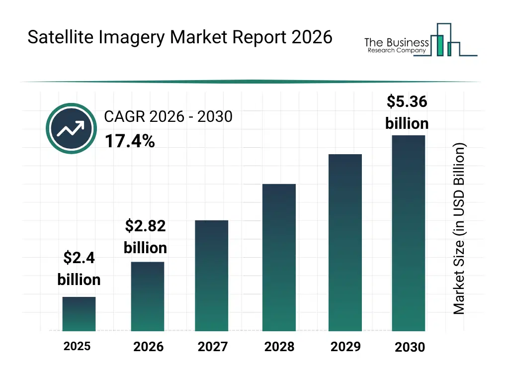
What Is The Satellite Imagery Market Size and Share 2026?
The satellite imagery market size has grown rapidly in recent years. It will grow from $2.4 billion in 2025 to $2.82 billion in 2026 at a compound annual growth rate (CAGR) of 17.2%. The growth in the historic period can be attributed to rising demand for geospatial intelligence data, increasing defense surveillance requirements, expansion of environmental monitoring initiatives, advancements in satellite sensor technologies, growing adoption of satellite-based mapping applications.What Is The Satellite Imagery Market Growth Forecast?
The satellite imagery market size is expected to see rapid growth in the next few years. It will grow to $5.36 billion in 2030 at a compound annual growth rate (CAGR) of 17.4%. The growth in the forecast period can be attributed to increasing investments in next-generation earth observation satellites, growing demand for real-time monitoring and analytics solutions, expansion of smart city and infrastructure planning projects, rising adoption of satellite imagery for climate resilience programs, increasing government and commercial space sector investments. Major trends in the forecast period include increasing adoption of high-resolution earth observation imagery, growing demand for defense and intelligence surveillance applications, expansion of satellite-based disaster response and emergency management programs, rising use of satellite imagery for agriculture and natural resource monitoring, growing deployment of multi-sensor optical, radar, and infrared imaging technologies.
Global Satellite Imagery Market Segmentation
1) By Type: 0.3 Meter Resolution, 0.5 Meter Resolution, 1 Meter Resolution 2) By Application: Geospatial Data Acquisition, Navigation And Mapping 3) By End User: Government, Defense Subsegments: 1) By 0.3 Meter Resolution: Urban Planning And Smart Cities, Defense And Intelligence Surveillance, Critical Infrastructure Monitoring 2) By 0.5 Meter Resolution: Agriculture Monitoring, Environmental Monitoring 3) By 1 Meter Resolution: Regional Planning And Development, Large Scale Environmental Studies, Weather And Climate Observation SupportWhat Is The Driver Of The Satellite Imagery Market?
The expansion of government and defense applications is expected to propel the growth of the satellite imagery market going forward. Government and defense applications refer to the use of space-based optical and sensing technologies by military agencies and public institutions for purposes such as surveillance, reconnaissance, border monitoring, and national security intelligence. The expansion of government and defense applications is rising due to the growing need for real-time surveillance and secure intelligence gathering to strengthen border security, mission planning, and rapid response capabilities. The surge in government and defense investment directly amplifies the need for advanced satellite imagery capabilities, as high-resolution, real-time geospatial data becomes indispensable for mission planning, threat detection, and battlefield situational awareness. For instance, in May 2023, according to the Congressional Research Service (CRS), a US-based nonpartisan agency, the U.S. Department of Defense's fiscal year 2024 budget requested $26.1 billion for space-based systems, reflecting an increase of $4.4 billion, or 20%, compared to the fiscal year 2023 enacted level. Therefore, the expansion of government and defense applications is driving the growth of the satellite imagery industry.Key Players In The Global Satellite Imagery Market
Major companies operating in the satellite imagery market are Google LLC, Airbus SE, L3Harris Technologies Inc., Planet Labs PBC, Telespazio S.p.A., Spire Global Inc., China Great Wall Industry Corporation (CGWIC), BlackSky Technology Inc., ICEYE Oy, ImageSat International N.V., HawkEye 360, Satellogic Inc., Capella Space Corp., SpaceWill Info. Co. Ltd., Umbra Lab Inc., Synspective Inc., European Space Imaging GmbH, Planet Observer SAS, Earth-i Limited, Bhusatyam Technologies Private Limited, Pixalytics LtdGlobal Satellite Imagery Market Trends and Insights
Major companies operating in the satellite imagery market are focusing on developing advanced hybrid imaging services, such as OptoSAR technology, to improve all-weather Earth observation capabilities and enhance real-time geospatial intelligence applications. OptoSAR technology refers to an integrated satellite imaging system that combines optical imaging and synthetic aperture radar (SAR) capabilities to capture high-resolution Earth imagery in both clear and adverse weather conditions, including nighttime monitoring. For instance, in May 2026, GalaxEye, an India-based space technology company, launched Drishti, described as the world’s first OptoSAR satellite platform. The satellite combines optical and SAR imaging technologies to deliver continuous high-resolution earth observation data in day, night, and cloudy weather conditions. It supports applications such as defense surveillance, disaster management, agriculture monitoring, and infrastructure tracking.What Are Latest Mergers And Acquisitions In The Satellite Imagery Market?
In July 2025, Neo Space Group, a Saudi Arabia-based space and satellite services company, acquired UP42 for an undisclosed amount. With this acquisition, Neo Space Group aims to strengthen its Earth observation and geospatial intelligence capabilities by expanding access to satellite imagery, analytics, and data platform services for commercial and government applications. UP42 is a Germany-based geospatial data platform company that provides satellite imagery, Earth observation data, and geospatial analytics services.Regional Outlook
North America was the largest region in the satellite imagery market in 2025. Asia-Pacific is expected to be the fastest-growing region in the forecast period. The regions covered in this market report are Australia, Brazil, China, France, Germany, India, Indonesia, Japan, Taiwan, Russia, South Korea, UK, USA, Canada, Italy, Spain. The countries covered in this market report are Australia, Brazil, China, France, Germany, India, Indonesia, Japan, Taiwan, Russia, South Korea, UK, USA, Canada, Italy, Spain.What Defines the Satellite Imagery Market?
The satellite imagery market includes revenues earned by entities by providing services such as earth observation data services, image processing services, geospatial analytics, and mapping services. The market value includes the value of related goods sold by the service provider or included within the service offering. Only goods and services traded between entities or sold to end consumers are included.How is Market Value Defined and Measured?
The market value is defined as the revenues that enterprises gain from the sale of goods and/or services within the specified market and geography through sales, grants, or donations in terms of the currency (in USD unless otherwise specified). The revenues for a specified geography are consumption values that are revenues generated by organizations in the specified geography within the market, irrespective of where they are produced. It does not include revenues from resales along the supply chain, either further along the supply chain or as part of other products.What Key Data and Analysis Are Included in the Satellite Imagery Market Report 2026?
The satellite imagery market research report is one of a series of new reports from The Business Research Company that provides satellite imagery market statistics, including satellite imagery industry global market size, regional shares, competitors with a satellite imagery market share, detailed satellite imagery market segments, market trends and opportunities, and any further data you may need to thrive in the satellite imagery industry. This satellite imagery market research report delivers a complete perspective of everything you need, with an in-depth analysis of the current and future scenario of the industry.Satellite Imagery Market Report Forecast Analysis
| Report Attribute | Details |
|---|---|
| Market Size Value In 2026 | $2.82 billion |
| Revenue Forecast In 2030 | $5.36 billion |
| Growth Rate | CAGR of 17.4% from 2026 to 2030 |
| Base Year For Estimation | 2025 |
| Actual Estimates/Historical Data | 2020-2025 |
| Forecast Period | 2026 - 2030 |
| Market Representation | Revenue in USD Billion and CAGR from 2026 to 2030 |
| Segments Covered | Type, Application, End User |
| Regional Scope | Asia-Pacific, Western Europe, Eastern Europe, North America, South America, Middle East, Africa |
| Country Scope | The countries covered in the satellite imagery market report are Australia, Brazil, China, France, Germany, India, Indonesia, Japan, Taiwan, Russia, South Korea, UK, USA, Canada, Italy, Spain. |
| Key Companies Profiled | Google LLC, Airbus SE, L3Harris Technologies Inc., Planet Labs PBC, Telespazio S.p.A., Spire Global Inc., China Great Wall Industry Corporation (CGWIC), BlackSky Technology Inc., ICEYE Oy, ImageSat International N.V., HawkEye 360, Satellogic Inc., Capella Space Corp., SpaceWill Info. Co. Ltd., Umbra Lab Inc., Synspective Inc., European Space Imaging GmbH, Planet Observer SAS, Earth-i Limited, Bhusatyam Technologies Private Limited, Pixalytics Ltd |
| Customization Scope | Request for Customization |
| Pricing And Purchase Options | Explore Purchase Options |